
Wootton Creek
Wootton Creek is one of the lovelier creeks in The Solent, with wooded valleys sweeping down to a winding creek. Midway between Cowes and Ryde, it was once used by trading sailing vessels visiting the brickworks at Ash Lake, and the tide mill at the head of the creek where the Sloop Inn now stands.
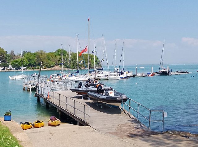
Image Credit: Royal Victoria Yacht Club
Today, there is little left apart from the old names. If trading barges could navigate to the head of the creek, then visiting yachts should easily make their way at least as far as the pontoons of the Royal Victoria Yacht Club (RVYC) at the entrance to the creek.
It should be remembered that those skippers worked their tides, and even today 70 foot ketches drawing over 8 foot have laid alongside the RVYC pontoons, but have swiftly departed once the tide is on the ebb.
An ideal time to visit is when High Water is over a lunchtime, meaning a good height of tide, and time to sample the RVYC hospitality at its bar and dining room. It is well-liked by visitors, and popular with rallies, and as a destination for passage races.
Be aware that the direction of buoyage in the eastern Solent is from east to west. Pilotage is straightforward with a compass, dependable echo sounder, and a good lookout.
The entrance to Wootton Creek is beset by hazards to the east and west. It is a busy car ferry port, with regular Wightlink sailings throughout the day and night. To the east, are drying gravel banks that have been known to embarrass a passing ferry. To the west are rock ledges coming out from the shore, and the dangerous Wootton Rocks themselves. Yachts close inshore may have local knowledge and lifting keels!
The entrance to Wootton Creek is best taken from the north cardinal, Wootton Beacon. It lies approximately 3.5nm from Cowes and only 1.5nm from Ryde Pier. It is best approached an hour or so either side of High Water on the first attempt. The ferry fairway is lit, with an occulting sectored light, and there is plenty of shore lighting on the link-span.
No matter from which point of the compass you’re approaching, it is best to stay to the north of Wootton Beacon for your approach. Once at Wootton Beacon, if safe from entering and departing ferries, turn southwest and run down the western side of the ferry channel, staying outside of the channel itself.
Keep an eye on the echo sounder, there should be plenty of water, if there isn’t, then you won’t get very far into the creek! Be aware that you may find ferries waiting to dock at the ferry terminal to the west of the fairway.
By the time you come to No. 7 dolphin, you’ll see the ferry link-span on your port hand, and the Wootton Creek port and starboard buoys ahead of you; these are maintained and positioned as needed by the King’s Harbour Master (KHM) at Portsmouth. Head through them, and if heading further up the Creek you will see the leading marks off to starboard on the opposite bank.
If calling at the RVYC, you will see their pontoons ahead of you. The northernmost pontoons are private, RVYC pontoon mooring is available past the visible sign. Berthing is straightforward, but be aware that at some states of tide there will be some flow across the pontoons. Do not approach through the private RVYC moorings, or indeed try to pick up one, as there are countless pick-up buoys and lines. If vessels are already berthed alongside hail and askto raft up. You may be asked to move your boat to accommodate other visitors. (Pontoon fees can be paid at the RVYC bar, or if the club is closed, you can also pay by BACS direct to the club’s account.) There is fresh water on the pontoons, showers and toilets in the clubhouse, a slipway, waste facilities, and an excellent bar and catering. Please check for opening hours and information for visitors are available on the website (see below).
The creek alongside the pontoons will dry, so unless you are prepared to take the ground, you must depart once the ebb starts to make. The water will seem to empty quite slowly for the fi rst couple of hours, but be aware that around the third hour the tide goes away very quickly; do not linger over that last pint at the bar! The bottom is irregular in shape and consistency, and careful fendering, tending of lines, and a watchful eye is needed as your vessel takes the ground.
The speed limit in the creek is 5 knots. The tidal current is relatively benign, seldom reaching above 4 knots although just after High Water at Springs, the sluice gates under Wootton Bridge are opened considerably, increasing the flow in the upper reaches. There are no visitor moorings in the creek and anchoring in the channel is prohibited. Anchoring outside the channel is not recommended due to the proliferation of abandoned ground chains and other mooring tackle. There is a Council-owned public slipway suitable for small vessels between the Sloop Inn and the bridge at the head of the creek.
The village of Wootton Bridge offers a full range of facilities: take aways, tea room, launderette, doctor and vet, supermarket and wine warehouse; just outside the village is a garage. It’s about 30 minutes walk from the RVYC, or take the dinghy up the Creek on the tide and land on the public slipway on the west bank at the head of the creek, right by the Sloop Inn.
Contact: Royal Victoria Yacht Club, 91 Fishbourne Lane, Fishbourne, Isle of Wight, PO33 4EU. Tel: 01983 882325. Email: office@rvyc.org.uk. Website: rvyc.org.uk
Please note, this information is to be used as a guide only and not for navigation.