
Solent Cruising
The Solent is renowned as one of the most popular recreational boating areas in the world but it’s much more than that. Formed around 7,000 years ago, when the Solent river estuary gradually flooded at the end of the last ice age, the Isle of Wight became separated from the mainland as the chalk ridge between The Needles and Old Harry Rocks on the mainland eroded.
Today, the Solent has more small estuaries in close proximity than anywhere else in Great Britain and is located in one of the most sheltered channels in Europe. It is unique in Europe for its complex tides and the long periods of stand at High and Low Waters.
The wide range of marine habitats make the Solent of international significance for wildlife, and one of the most important sites on the bird migration routes from the Arctic to Africa. With its huge diversity of wildlife and habitats, along with its heritage and archaeological importance, much of the coastline has protected status and is recognised as being of national and international importance.
The Solent’s unique characteristics have made Southampton the leading cruise port and one of the main commercial ports in the country and enabled Portsmouth’s maritime heritage and naval importance. Consequently, the Solent has a high level of shipping movements with vessels of all types being seen.
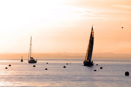
The huge diversity of the area together with the close proximity of many ports, harbours, and anchorages makes the Solent a wonderful cruising ground for sailors and powerboaters. The choice in number, size, and atmosphere of the many destinations in the Solent make it perfect for weekending or holiday cruising, especially when family cruising as there is much to satisfy all tastes.
While mid-sized and large yachts and powerboats tend to congregate in the larger yachting centres such as Lymington, Cowes, Hamble, and Portsmouth there are many other destinations and anchorages available to smaller craft and those who don’t wish to follow the well-plowed wakes of the majority.
The double high tides of the Solent add to its cruising benefits but the strength and complexities of the tidal streams must be taken into account when planning and making passages in the Solent.
Good weather information is readily available in this area, both actual and forecast, but make allowance for the fact that the geography of the area impacts on the wind as it does for the tides and many weather models do not accurately predict local Solent variations.
In summer, especially when the morning's gradient wind is northwest, look for a sea breeze from late morning, building through the afternoon when it can deliver a fresh southwesterly. If this is blowing against an ebb tide conditions can become quite choppy before calming down again as the sea breeze loses its power.
Approaches to the Solent
The Solent can be entered from the west or east. At the western end, the eroded chalk cliffs of The Needles, together with its iconic lighthouse, have been a welcome sight to many returning sailors over the centuries, while to the east, the more protected entrance is through the Forts, where Portsmouth and Spithead with all their maritime heritage greet the sailor's arrival.
From the west
Heading for the Solent from Poole or further west the obvious choice is to enter through the Needles Channel. In light to moderate conditions with a favourable tide the main Channel south of the notorious Shingles bank is benign, but if the ebb is running expect a more turbulent entry and if a west or southwest wind of more than Force 5-6 is fighting a strong ebb tide this is definitely a place to avoid. Breaking seas over The Bridge, rough water in the Channel, and overfalls in Hurst Narrows all await the incautious.
A far less vigorous option, which is much under-used, is the North Channel which is approached to the north of the Shingles and is much safer in rough weather. Stay to the north of the Shingles and leave North Head buoy to starboard, turning into the Channel which runs parallel to Hurst beach. When entering Hurst Narrows take care to avoid The Trap which is a steep-sided shingle spit extending out from the beach near the round fort. Once past, the shingle bank runs northeast and is fairly steep-sided with room to anchor for shelter or a lunch stop.
From the east
Arriving from the east, the main entrance is between Horse Sand Fort to the north and No Man's Land Fort to the south. If coming from Langstone or Chichester harbours there is a shorter route using the Main Passage in the submerged barrier between Horse Sand Fort and the mainland, or the Boat Passage close to the shore is available for small craft.
Since the submerged barrier between No Man's Land Fort was removed passage can be made inshore of the fort with a least depth of 2m over foul ground between the Fort and the red post to the southwest, which is useful when approaching from the south. Once past the fort make sure to avoid the extensive Ryde Sands by staying far enough north to clear the red post at the northeastern extremity of the Sands by a decent margin. Note that the Sands to the west of the post extend slightly north of it so don't cut the corner near Low Water.
The western Solent
The western Solent offers two different but attractive coastlines, varied wildlife habitats and less commercial traffic than the central or eastern parts. It has a wide area of navigable water for most yachts and motor cruisers, is well buoyed, and offers a great choice of harbours and anchorages within 8 miles.
With Keyhaven, Lymington, Beaulieu, Yarmouth, and Newtown all within easy reach the western Solent offers the choice between anchoring among beautiful scenery and wildlife, or picking a pontoon or mooring in attractive towns with good facilities and attractions.
At the western end, Keyhaven is often missed but is good to explore near High Water or for a lunch-stop anchorage in the shelter of Hurst Spit. Lymington or Yarmouth are very popular stopping points in the western Solent while Beaulieu and Newtown are favourite haunts for peace and wildlife.
The volume of boats, both power and sail, during busy summer weekends and holidays mean that it can be difficult finding a berth in the popular areas and it is sensible to book ahead if possible or risk being unable to find a vacant berth or mooring, or even space to anchor.
Solent tidal streams always make it worthwhile working the tide in small boats, especially near Springs, but the location of the western Solent harbours makes them convenient for cross-tide visits. So if the tide doesn't serve for a passage from Lymington to Beaulieu, Newtown, or Cowes, a trip across to Yarmouth for lunch until the tide turns is an attractive detour.
When punching tide along the Solent, the greatest tidal relief is found to the north of the channel where the bottom is less steep-to than on the Island shore. When fighting tide along the Island shore beware Gurnard, Salt Mead, and Hamstead Ledges and make sure that you calculate the height of tide carefully if you choose to stay close to the shore.
Tidal streams in excess of 3.5 knots are experienced around Spring tides, particularly between Gurnard Ledge and Cowes, and between Yarmouth and Hurst Narrows. In strong wind against tide conditions, most commonly when an ebb stream meets a strong west or southwesterly wind, the seas in the western Solent can be steep and breaking, uncomfortable conditions for small to medium sized yachts or motor cruisers. Conditions are likely to be less rough north of the channel, in shallower water and out of the strongest tide.
When heading for Cowes from the western Solent in rough conditions stay in mid-Solent or further north until level with Egypt Point before heading for Cowes to avoid the roughest water off Gurnard Bay. If heading for the eastern Solent or Southampton Water stay slightly south of Lepe Spit to avoid the roughest water in the strong stream that flows around the Spit.
The central Solent
The central Solent is a busy place with commercial traffic from east and west converging to head up the Thorn Channel and into Southampton Water, along with ferries heading in and out of Cowes. The most important feature to avoid is the Brambles Bank, which lies at the western end of the Hill Head Plateau and borders the Thorn Channel to the east. This shallow patch claims many an unwary yacht or powerboat each season. Much yacht racing takes place on the Hill Head Plateau because of the tidal relief obtained here and considerate cruising sailors and powerboaters should avoid passing through the fleets of race boats.
Very large ships approach the Thorn Channel from the east, making the tight turn to starboard off Cowes to enter the channel. When the ebb is running vessels start their turn off Cowes while on the flood they turn later, near Gurnard cardinal buoy.
The size and density of the commercial traffic in this area together with their speed, makes it imperative to keep a good lookout. Remember that there is a Precautionary Area between Calshot and Cowes where all vessels over 150m are given a Moving Prohibited Zone of 1,000 metres ahead and 100 metres to either side. All vessels under 20m must stay clear of this moving zone.
To the north of the Brambles Bank, the North Channel provides access to Southampton Water for small commercial craft coming from the west, saving them the extra distance needed to round the Brambles to the south and the passage up the Thorn Channel. To the north of this channel the Hill Head and Lee-on-Solent shorelines are popular areas for dinghy sailing, windsurfing, kitesurfing, and jet skiing. Small recreational fishing boats are also found throughout the central Solent, often anchored on the plateau or near the shorelines.
The Solent's most famous port, Cowes, lies at the centre of the Solent and its convenient geographical position, plus its easy entry, make it a popular destination for yachts and powerboats of all types. As it is also the home of passenger and car ferry operations, plus commercial traffic headed up the River Medina, the entrance is often crowded and care should be taken when entering or leaving.
The tide off Cowes runs very strongly and due allowance for the strong east or west going stream should be made when entering or leaving as the stream changes direction in the harbour entrance.
When a strong wind meets a strong tide off Cowes the seas on Prince Consort Shoal can get quite lumpy. This can be avoided if coming from the east by staying inshore but beware of The Shrape mud which at low tide extends almost as far as the racing buoys, and do not be tempted to cut through the extensive mooring buoys which line the east side of the harbour. Round No. 2 red can at the entrance before heading upriver.
The other main yachting harbour in the central Solent is the Hamble River with its many marinas and yachting facilities. Southampton Water has much commercial traffic but there are still places for the leisure sailor to explore including Ashlett Creek on the west side below the Fawley Marine Terminal jetties. Further up Southampton Water is Hythe Marina Village on the west side, while Ocean Village Marina is just beyond Southampton Dockhead up the River Itchen with Shamrock Quay and Saxon Wharf a bit further on beyond the Itchen Bridge. Small boats have plenty of exploration available to them in both the rivers Test and Itchen.
The eastern Solent
The eastern Solent has a different character to the western arm and the mainland shore is more developed. The sand and gravel sea bed which predominates to the west gives way to a greater proportion of mud in the east. Cross-Solent ferry traffic is high with car ferries operating between Portsmouth and Fishbourne at the entrance to Wootton Creek. Fast passenger catamarans run between Portsmouth and Ryde Pier head while the last remaining passenger hovercraft service runs between Southsea and Ryde.
The major deep water shipping channel is south of Ryde Middle bank and very large ships regularly transit the area, with outgoing and incoming vessels often passing in the eastern Solent. Yachts and powerboats using this area should try to avoid the main channel, either staying to the south of the channel in ample water off the Island shore, or passing over Ryde Middle bank to the north of the main channel. The North Channel runs to the north of Ryde Middle bank and is used by smaller commercial and military craft. The eastern Solent is also often busy at weekends and in high summer with yachts racing.
On the Island shore, Osborne Bay, just to the east of Cowes, is a popular day-time or overnight anchorage as it is well sheltered from west or southwest winds and has an attractive shoreline. Just to the east, Wootton Creek is nice to explore in a small boat and when the tide serves but the entrance is dominated by the car ferry terminal and caution is needed when ferries are arriving and leaving.
Further east is Ryde Pier and, beyond, the small Ryde Harbour which is accessible only around high tide and by small to medium sized shallow draft boats. Ryde Sands is the major obstacle in this area and this extensive sandbank catches out many unwary craft.
To the north, the coastline turns northeast at Gilkicker Point and runs to the narrow entrance to Portsmouth Harbour. Portsmouth has much to offer the sailor or powerboater looking for exploration with a variety of marinas and opportunities for anchoring. Beyond the forts to the east lie Langstone and Chichester harbours, both of which have bars at their entrances which make it unsafe to enter or leave in rough conditions, such as when a strong southerly wind opposes a strong ebb tide. Both harbours are superb boating areas that are particularly appealing to owners of small yachts and powerboats who enjoy exploring, creek crawling, and wildlife watching.
Together with the varied ports, harbours, and anchorages within the Solent, Langstone and Chichester make up the most compact yet varied cruising ground in Europe, a real treasure to be enjoyed and protected.